


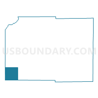
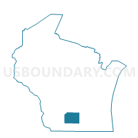
PERRY - T 1 Voting District, Dane County, Wisconsin
About
Outline

Summary
| Unique Area Identifier | 693172 |
| Name | PERRY - T 1 Voting District |
| County | Dane County |
| State | Wisconsin |
| Area (square miles) | 36.11 |
| Land Area (square miles) | 36.11 |
| Water Area (square miles) | 0.00 |
| % of Land Area | 100.00 |
| % of Water Area | 0.00 |
| Latitude of the Internal Point | 42.90111290 |
| Longtitude of the Internal Point | -89.77931880 |
Maps

Graphs
Select a template below for downloading or customizing gragh for PERRY - T 1 Voting District, Dane County, Wisconsin


Neighbors
Neighoring Voting District (by Name) Neighboring Voting District on the Map
- BLUE MOUNDS - T 1 Voting District, Dane County, WI
- BRIGHAM - T 2 Voting District, Iowa County, WI
- MOSCOW - T 1 Voting District, Iowa County, WI
- NEW GLARUS - T 1 Voting District, Green County, WI
- PRIMROSE - T 1 Voting District, Dane County, WI
- SPRINGDALE - T 1 Voting District, Dane County, WI
- YORK - T 1 Voting District, Green County, WI
Top 10 Neighboring County Subdivision (by Population) Neighboring County Subdivision on the Map
- Springdale town, Dane County, WI (1,904)
- New Glarus town, Green County, WI (1,335)
- Brigham town, Iowa County, WI (1,034)
- Blue Mounds town, Dane County, WI (968)
- York town, Green County, WI (910)
- Primrose town, Dane County, WI (731)
- Perry town, Dane County, WI (729)
- Moscow town, Iowa County, WI (576)
Top 10 Neighboring Unified School District (by Population) Neighboring Unified School District on the Map
- Mount Horeb Area School District, WI (12,121)
- New Glarus School District, WI (4,667)
- Pecatonica Area School District, WI (2,745)
- Barneveld School District, WI (2,288)
Top 10 Neighboring State Legislative District Lower Chamber (by Population) Neighboring State Legislative District Lower Chamber on the Map
- Assembly District 79, WI (76,116)
- Assembly District 80, WI (60,352)
- Assembly District 51, WI (57,687)
Top 10 Neighboring State Legislative District Upper Chamber (by Population) Neighboring State Legislative District Upper Chamber on the Map
Top 10 Neighboring 111th Congressional District (by Population) Neighboring 111th Congressional District on the Map
Top 10 Neighboring Census Tract (by Population) Neighboring Census Tract on the Map
- Census Tract 9602, Green County, WI (5,684)
- Census Tract 9505, Iowa County, WI (4,755)
- Census Tract 126, Dane County, WI (4,389)
- Census Tract 127, Dane County, WI (3,867)
Top 10 Neighboring 5-Digit ZIP Code Tabulation Area (by Population) Neighboring 5-Digit ZIP Code Tabulation Area on the Map
- 53572, WI (9,970)
- 53574, WI (3,877)
- 53507, WI (2,196)
- 53516, WI (2,152)
- 53517, WI (1,752)
- 53544, WI (800)